Ampato volcano


Caylloma, Arequipa, Peru
Suggest Place to Visit
574
Track to location with GPS |
 |
According to carbon 14 tests, the first expedition to climb the volcano was an Inca and it did so in 1466. Since those times, Ampato has been considered an "Apu" or guardian god of the area, causing misfortunes when it erupts (it fits note that it is now a dormant volcano). For this reason, the settlers, to calm him, formerly gave him offerings. One of those offerings was the beautiful Lady of Ampato, a 12 or 14 year old girl who was chosen among the best women in the kingdom of Pachacútec. It is only known today, due to the discovery made in 1995, that his death was a religious ritual of great importance in ancient Peru.
Juanita was discovered thanks to the fumaroles of the Sabancaya volcano, which caused the glacial mass at the top of Ampato to recede a few meters, thus thawing the Juanita mummy or "Lady of Ampato". This archaeological relic was found 150 meters below the main summit of the volcano, thus opening the way for archaeological mountaineering.
Along with other mountains in Arequipa, Ayacucho and Alta Catamarca in Argentina, Ampato is part of a project called "Andean Sanctuaries", the purpose of which is to search and study mummies and pre-Hispanic Andean vestiges in the peaks and surroundings of the mountainous massifs mentioned.
Returning to the issue of expeditions, the first recorded ascent took place in 1966 and was led by R. Culbert, the first athlete to reach the main peak of Ampato.
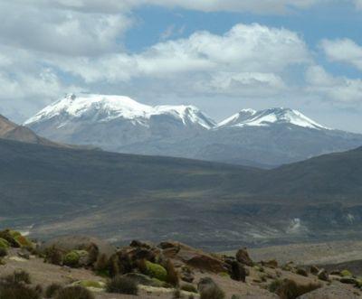
The Ampato volcano has two peaks, the north one, over 6050 m.a.s.l., and the south and main one, at 6318 m.s.n.m.
It belongs to the Ampato mountain range which, together with the Volcanic mountain range and the Chila mountain range, is part of the three main mountain ranges of the department.
The volcanoes that surround it are the Sabancaya and the Hualca Hualca.
It is located in the department of Arequipa, province of Caylloma, 80 kilometers northwest of the city of Arequipa and on the south side of the Colca Canyon. It is part of the Cordillera de Ampato.
Coordinates: 15 ° south longitude, 71.9 ° west latitude. It is necessary to hire the services of a 4x4 vehicle from Arequipa to the slopes of Ampato. The route used is the Arequipa-Chivay highway to Patapampa, from where a 30-kilometer detour is taken to Sallallí. Finally, we continue along a paved track to the base camp, at 4600 m.a.s.l., the starting point for the ascent.
The journey from Arequipa is 165 kilometers long, with a duration of 5 hours.
Snowy climate, with temperatures below 0 ° Celsius. There are permanently snowfalls, blizzards, storms and hail.
There are three ways to reach the summit:
East side: normal route, east slope, crossing the north summit.
It begins at the base camp (4600 m.a.s.l.) and climbs in a northwesterly direction along slopes of rock and snow until reaching platforms suitable for installing field 1 (5400 m.s.n.m.), 4 or 5 hours after starting the ascent.
From here we continue uphill towards the east and then turn south and pass the north summit (6050m.s.n.m.). Complications culminate at this point; the continuation of the path is easier and in 6 hours the south summit is finally reached.
The return is made in 3 hours to camp 1 and in 1.5 hours to base camp.
East side: slope; southeast ridge.
From the base camp you walk 2 kilometers to the edge of the gorge “el glaciar” (4900 m.s.n.m.), where an advanced base camp is installed. The journey continues when it comes across a defined rocky ridge (lure of the road) and climbs the snow slopes until reaching the main summit, the south. The journey from the slope takes between 8 or 9 hours. The descent takes 4 hours and follows the same route as the ascent.
West side: Mucurca-Cabanaconde route
It is an extremely long route (7 days round trip) and very little frequented. It begins in the town of Cabanaconde, in the Colca Canyon, and uses Inca trails, crossing beautiful places such as the Mucurca lagoon (4300 m.a.s.l.).
Promotion season
Between April and November. Although the Ampato does not show ascent difficulties, it is important to go with the necessary mountain equipment (boots with crampons, poles, glasses, gorotex clothing, ice axes, etc.) and with specialized guides who know the route perfectly.
Comments
We don´t have yet any comments about:
Ampato volcano
Ampato volcano
Be the first to leave a comment as it is very important to inform other people
Outros locais a visitar
Within a radius of 20 km from:Ampato volcano
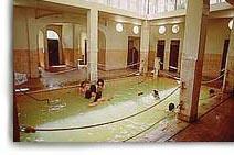
Baños Termales de Yura |
| 1,1 Km |
 |
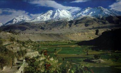
Nevado de Chachani |
| 16,7 Km |
 |
Hotel reservation near Ampato volcano within a radius of 20 km

Why to book with RUTAS TURISTICAS
The best prices
Our partnerships with the world´s largest operators offer research on the best market prices.
More options
At Rotas Turisticos you can book the hotel, buy the air ticket, book the transfer from the airport to the hotel and vice versa, book the local excursions, rent the car, take travel insurance and consult the places to visit and where to go.
Holiday Tips & Destinations
Hundreds of holiday destinations with all the options that allow you to easily choose the destination that best suits your dream vacation.
RUTAS TURISTICAS
Links
Follow us on social networks


